
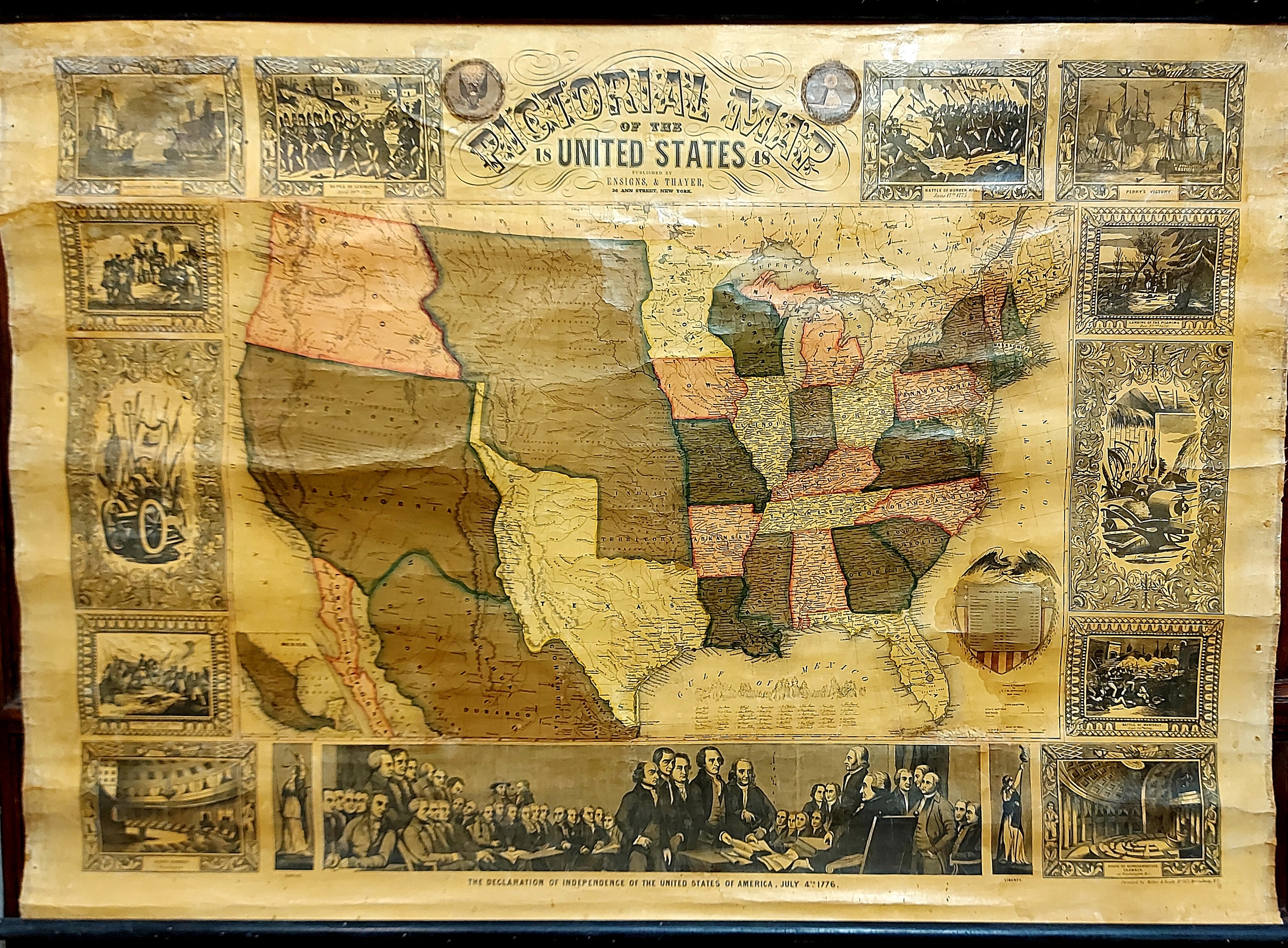
Carta geografica telata degli Stati Uniti d’America, disegnata e incisa in rame da J. M. Atwood, cm 112 x 80 circa, montata su supporti originali in legno. Alcune rotture marginali, abrasioni e segni di stazzonatura. Seconda edizione del 1848 di questa nota e importante carta geografica degli Stati Uniti la cui edizione originale risale all’anno precedente (1847 per la stampa di Ensign, Thayer e Phelps), e che poi conobbe anche edizioni successive nel 1849 e 1850. La cartina centrale è circondata da 15 vignette illustrate lungo i 4 lati (11 illustrazioni con episodi di storia americana, 2 illustrazioni della Giustizia e della Libertà personificate, 2 grandi illustrazioni con simboli: armature e armi, e attrezzi agricoli). Le illustrazioni raffigurano: l’arrivo di Cristoforo Colombo, la Constitution contro la Guerriere, la battaglia di Lexington del 1775, la battaglia di Bunker Hill del 1775, la vittoria di Perry, l’arrivo dei Padri Pellegrini, la battaglia di Monterey, la Camera dei Rappresentanti di Washington, la dichiarazione d’indipendenza, la Camera del Senato, la cattura del Generale La Vega. La città di San Francisco presenta ancora il nome spagnolo dell’insediamento originale, ovvero Yerba Buena, toponimo che compare solamente nelle cartine uscite tra 1846 e 1849. E’ presente inoltre la Nueva Helvetia, la colonia fondata nell’area di Sacramento nell’agosto 1839 dallo svizzero John Sutter (la città di Sacramento non è quindi ancora indicata), mentre il Texas è delineato con la vecchia configurazione detta “stovepipe” (a tubo di stufa). “The border of J. M. Atwood’s Pictorial Map of the United States displays fifteen picture inserts borrowed from popular historical prints and print specimen handbooks. Viewed individually, each picture showed an aspect of the nation’s origin story, stretching from the ‘Landing of Columbus’ and the ‘Landing of Pilgrims’ to land and sea battles of the Revolutionary War and War of 1812 (Perry’s Victory) to the more recent Mexican American War. These historical vignettes were truncated on both sides of the map by allegorical still lifes representing the tools of war and peace, showing the nation’s colors and armory on the left, delineating plows and other agricultural equipment on the right…” (Bruckner, “The Social Life of Maps in America, 1750-1860″, 2017, p. 221).
SKU: 32 n.584
4.500,00 €


![Eira [cartine]](/images/books2/2014_eelopytyun.jpg)